
Geology of northern Idaho and the Silver Valley
Northern Idaho contains rocks of both the Omineca crystalline belt and the foreland fold belt of the Cordilleran orogenic system. The foreland belt rocks are found on the eastern and western sides of the Idaho panhandle and consist of Middle Proterozoic Belt Supergroup strata; these rocks host the ore deposits of the Coeur d’Alene district. Further information about the Belt Supergroup can be found in Module 2 on the Digital Geology of Idaho.
PDF slideshows: North Idaho slideshow by Jim Cash.
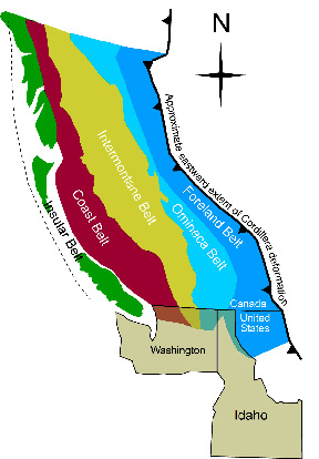
(Above) Northern Idaho contains rocks of both the Omineca crystalline belt and the Foreland fold belt of the Cordilleran orogen.
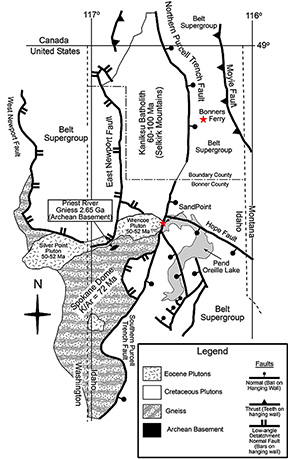
(Above) Geologic map of Priest River core complex in northern Idaho (adapted from Doughty et al., 1997; Doughty and Price, 2000).
Coeur d’Alene mining district
Idaho's Silver Valley, the Coeur d'Alene mining district, is in the South Fork of the Coeur d'Alene River in the panhandle of northern Idaho. The Coeur d'Alene mining district has one of the world's largest concentrations of silver metal. Since 1884, the district has produced over 1.18 billion ounces of silver, along with major amounts of lead, zinc, copper, and antimony. In total, more than $2.89 billion worth of metal has been produced from veins in the district.
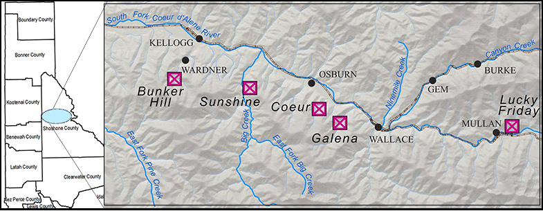
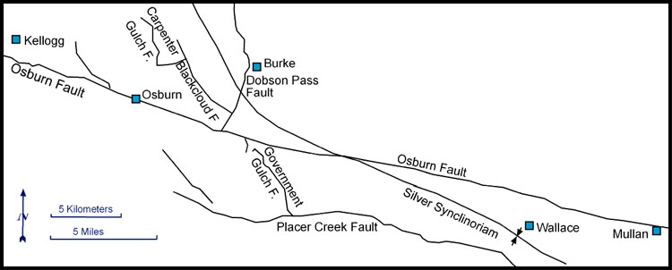
(Above) Map of the Coeur d'Alene mining district, with some of the major mines labeled.
Gold was discovered on the South Fork of the Coeur d’Alene River in 1878. The gold rush lasted only a few years. In 1884 the first major lead-zinc-silver discovery was staked, and all of the major mines were found within a year. Of 90 mines historically in the district, only two were still operating in 2007 (the Lucky Friday and the Galena), and another (the famous Sunshine mine) was being targeted for reopening. The Coeur d'Alene district contains the largest underground mine in the United States (the Bunker Hill Mine, with over 150 miles of workings), the deepest mine (the Star-Morning, which is over 7,900 feet deep), and the richest silver mine (the Sunshine, which has produced over 367 million ounces of silver).
The below figure shows the geology of the Coeur d’Alene district. The mines are in the Proterozoic rocks of the Belt Supergroup. Intrusive rocks include the Cretaceous Gem and Dago Peak stocks and diabase and lamprophyre dikes of uncertain age. The district lies within the Lewis and Clark fault zone or shear zone, which is composed of many separate northwest-striking faults.
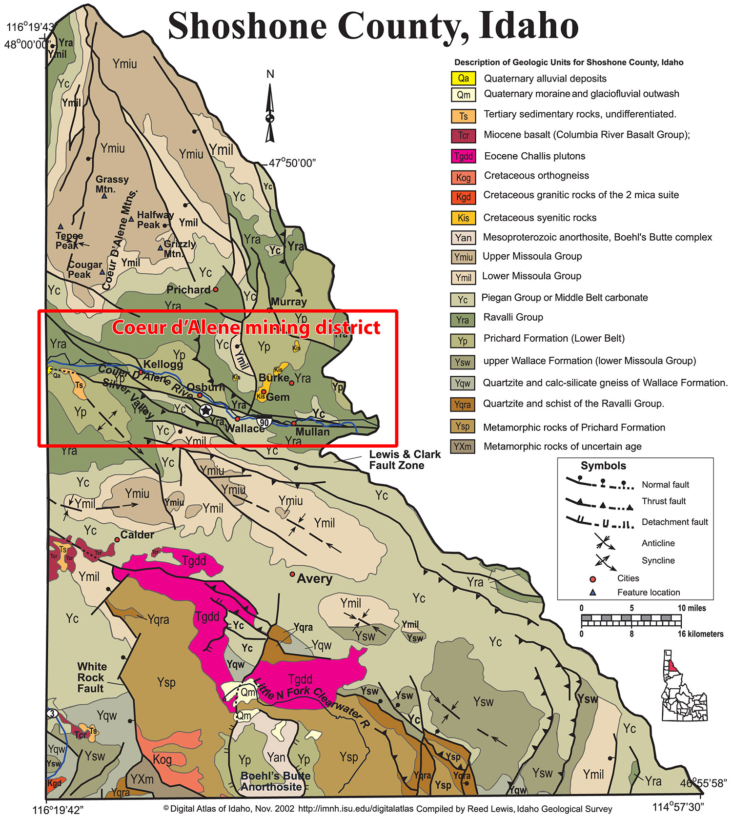
(Above) Generalized geology of the Coeur d’Alene district (modified from Lewis, 2002 Digital Atlas of Idaho).
Stratigraphy: Host Rocks of the Coeur d’Alene District
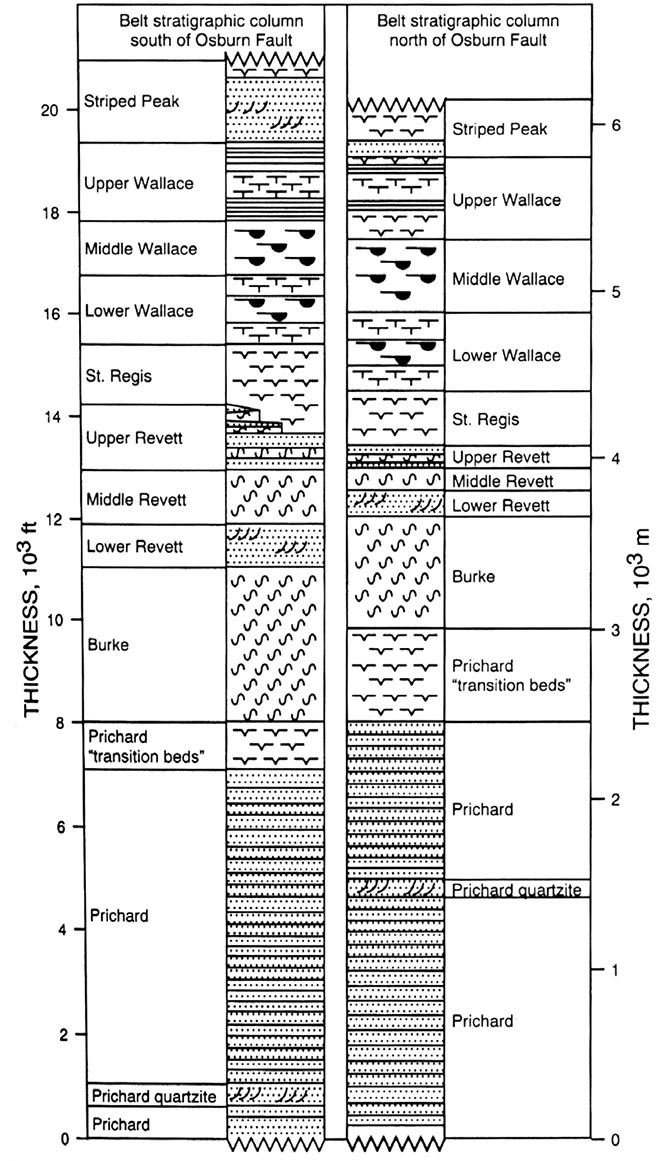
(Right/below) Stratigraphic column of the Belt Supergroup in the Coeur d’Alene district (Winston, 2000). The mines of the Coeur d’Alene district are hosted by the Proterozoic Belt Supergroup (see Module 2) that is about 1.4 billion years old. Most of the ore is in the Revett-St. Regis transition zone, the Prichard-Burke transition zone, and the middle Prichard Formation quartzite (Bennett, et. al, 1989; Winston, 2000).
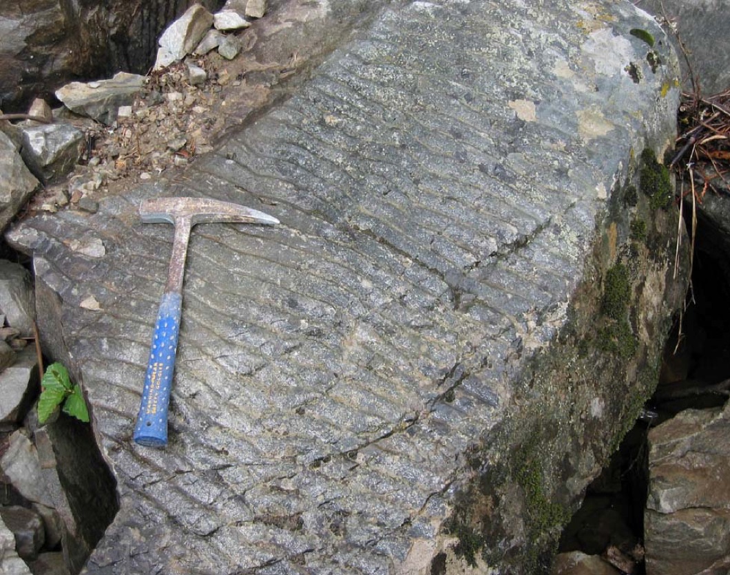
(Above) Close-up of ripple marks in quartzite from outcrop with foreset bedding, Palouse River, Highway 2, Bonner County (Jim Cash photo).
Structure: Faults & folds
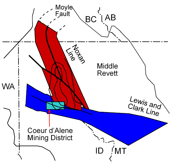
(Left/Above) Sketch map showing location of the Coeur d'Alene district in relation to the Noxon arch (Noxon line) and the faults of the Lewis and Clark shear zone (White, 2000). The structural geology of the area is complicated by a variety of folds and faults of diverse ages and movements. The district is at the intersection of the west-northwest-striking Osburn fault and a north-trending anticlinal uplift called the Noxon arch (White, 2000).
Complex fold and fault structures are present, and pronounced facies and thickness changes in the Belt sedimentary host strata suggest that tectonism affecting the district began early (White, 2000). Abrupt southward stratigraphic thickening across the Coeur d’Alene district in the Belt Supergroup strongly suggests prolonged down-to-the-south faulting during most of the Belt deposition (Winston, 2000). The Cretaceous to Paleocene compressional folding and thrusting, accompanied by metamorphism, and the later Tertiary normal and strike slip faults are narrowly focused and superimposed, making the structural geology of this region even more complex (Hobbs and others, 1965).
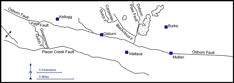
(Above) Map showing locations of some of the faults in the Coeur d’Alene district. Circles, diamonds, and triangles mark the locations of most of the mines that have produced ore (Bennett, 1984). The Lewis and Clark shear zone is a 50 km wide, structurally and topographically defined lineament that crosses the Belt Supergroup and extends for at least 300 km. The zone includes the Placer Creek fault and the Osburn fault.
(Above) Map elements can be rearranged to show what the district would have looked like before the faults moved. Map above shows Coeur d'Alene district before movement along the Osburn and Dobson Pass faults (Bennett, 1984). Also see Bennett and Venkatakrishnan (1982).
Geology of the Idaho Panhandle
The scope of this section will focus on rocks found on the central-western portion of the panhandle, namely the Priest River core complex and associated rocks. Though poorly defined, it is implied that the Priest River core complex is composed of the Kootenay Arc terrane (Orr and Orr, 2002), the Belt Supergroup, and the underlying Hearne province (Doughty et al., 1997) (also see Module 1 and Module 2).
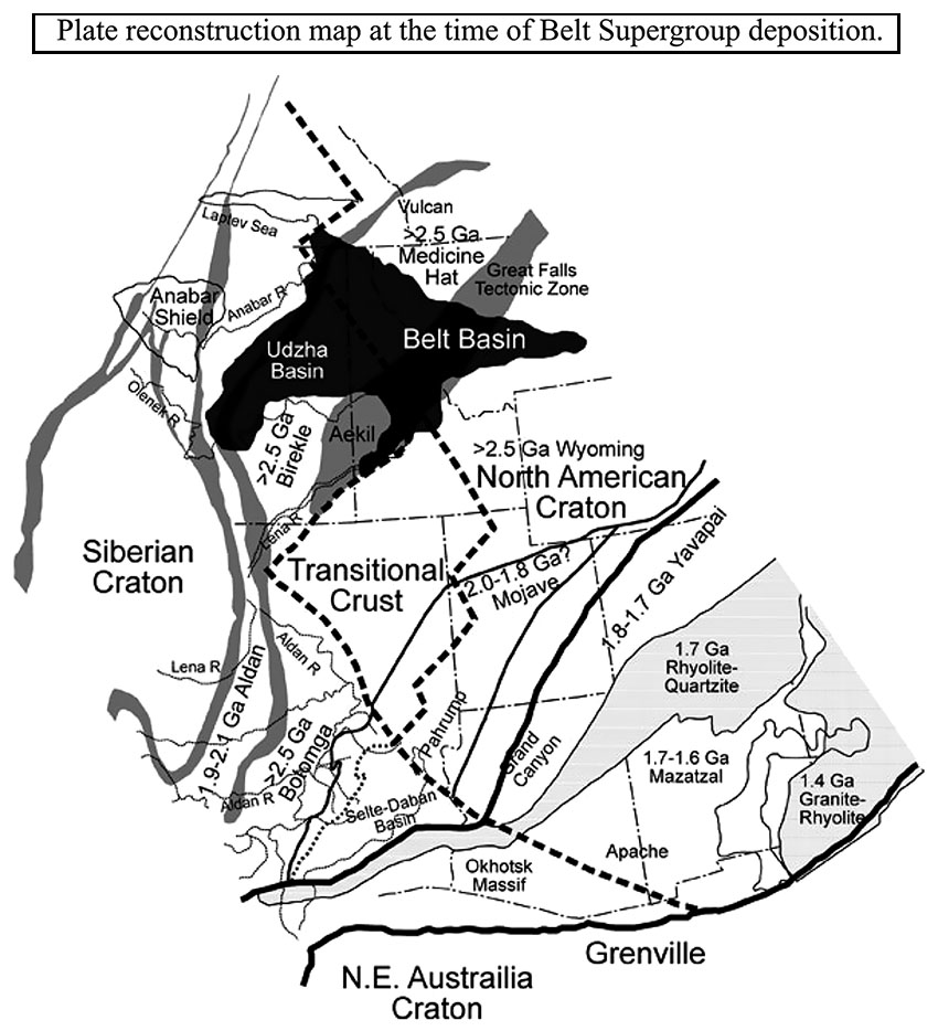
(Left/Above) Regional map showing plate reconstruction at the time of Belt Supergroup deposition (modified from Sears). The Hearne/Medicine Hat Province (northern extent of figure) is ~2.5 Ga basement with the same age basement material found in the Spokane dome region of the core complex (Doughty et al., 1997).
The Archean basement is located southwest of the Eocene Wrencoe pluton, in the northern area of the Spokane gneiss dome. Doughty et al. (1997) have mapped a metaquartzite unconformably above the Archean basement that is believed to be equivalent to the Prichard Formation of the Belt Supergroup. It is named the Gold Cup Mountain quartzite, after the locality of the same name.
The Kootenay Arc is the easternmost terrane of the Omineca Belt and is believed to have begun docking with North America between 190 and 160 Ma (Orr and Orr, 2002). Subsequent collisions of other terranes to the west further compressed the Kootenay Arc which consists largely of sedimentary strata. The Spokane dome is mainly comprised of the Hauser Lake gneiss, a mylonitized migmatitic paragniess. Peak metamorphism occurred around 72 Ma (Doughty et al., 1997) recording the highest pulse of compression during the Mesozoic orogenic event. Deformation led to thickening and ultimately to melting and subsequent injection of plutons (Orr and Orr, 2002). This is evidenced by the Cretaceous Kaniksu Batholith, which make up the north south trending Selkirk Mountains, located in the northern portion of the core complex (Figure 2). The Kaniksu Batholith is a mixture of granite and granodiorite (Doughty and Price, 2000).
During Mesozoic deformation the Purcell Trench and Purcell Anticlinorium formed, separating the highly metamorphosed Priest River core complex to the west and the relatively undeformed Belt Supergroup to the east (Figure 2). This relationship produced the argument that the Purcell Trench marks the western extent of the North American Craton (Orr and Orr, 2002). If the Purcell Trench marks the North American boundary and because Hauser Lake gneiss is to the west of the Purcell Trench it would make the Hauser Lake gneiss part of the Kootenay Arc.
However the presence of Belt Supergroup rocks in the hanging wall west of the core complex is an argument that core is probably the western most edge of North America. An implication of this is that the Kaniksu Batholith is intruding North America, not the Kootenay Arc Terrane. Doughty et al. (1997) suggests the mylonite zone above the metaquartzite is the décollement of the Rocky Mountains (thrusting occurred in mid-Cretaceous to Paleocene time) making Gold Cup Mountain a window through the metaquartzite (metamorphosed Belt Supergroup) into the crystalline Archean basement (2.5 Ga Medicine Hat Province) underlying the Belt Supergroup. The Purcell Trench is obscured by Quaternary glacial fill making relationships across the trench hard to characterize.
Eocene Extension
During the Cenozoic, 52 Ma, crustal shortening from the Sevier-Laramide orogeny ceased and the rocks in northern Idaho began to relax, resulting in crustal collapse that was accommodated by normal faulting. This created a series of grabens, thinning the crust. The reduction of overburden created increased magmatism and pluton emplacement as evidenced by the Wrencoe, Silver Point, and other plutons (Doughty et al., 1997; Doughty and Price, 2000; Orr and Orr, 2002).
Continued extension also resulted in the formation of low-angle normal faults, also called detachment faults. Tens of kilometers of displacement along these faults is common, allowing the removal of overlying, younger rock and permitting glimpses into the “core” of the crust. Displacement along the Newport fault to the North and the Purcell Trench fault to the east may have facilitated creation of the Priest River metamorphic core complex, allowing deep crustal material to be exposed on the surface (Doughty et al., 1997; Doughty and Price, 2000; Orr and Orr, 2002).
The Purcell Lobe of the large Cordilleran Ice Sheet covered the region gouging out what is now Pend Oreille Lake.
Geology of the Ore Veins . . . Tetrahedrite, Galena, and Sphalerite . . .
The mineral veins in the district consist principally of siderite (tan-colored iron carbonate) with quartz and sulfide minerals, principally tetrahedrite (a silver-rich, copper-antimony sulfide), galena (lead sulfide), sphalerite (zinc sulfide), and chalcopyrite (copper-iron sulfide). They extend over a mile below the surface. Many veins are localized along faults and fractures in more brittle quartzite units, but the deposits also show some stratigraphic control. Research on the age and origin of the Coeur d'Alene veins has been a controversial subject over the last century. The most recent thinking is that the metals were originally deposited along with the Precambrian sediments and that veins probably formed in the Cretaceous about 65 120 million years ago (Fleck and others, 2002).
Veins range from centimeters to several meters in width, are persistent over long strike lengths, and extend to great depth. Veins show little vertical mineral zoning, although some veins, such as the Star-Morning, change along strike with the Star being zinc rich and the Morning lead silver rich. Deformation after emplacement is evident in many of the veins.
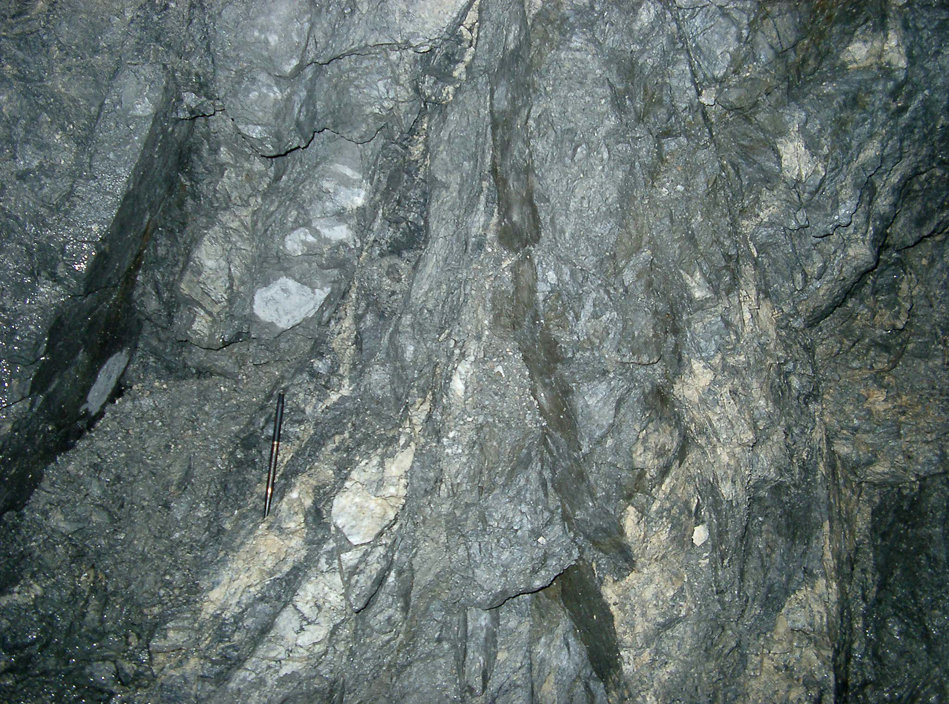
(Above) Underground vein in the Galena mine. (V.S. Gillerman photograph, 2003). Most of the ore bearing veins occupy one of three stratigraphic horizons. (Figure 11) The Prichard Formation near the middle quartzite (zinc-rich deposits), the Prichard Burke transition zone (lead-zinc-rich deposits), company built its own smelter in 1917 and an electrolytic zinc plant (with and Revett St. Regis transition zone (lead-silver-copper-rich deposits (Bennett, 1984).
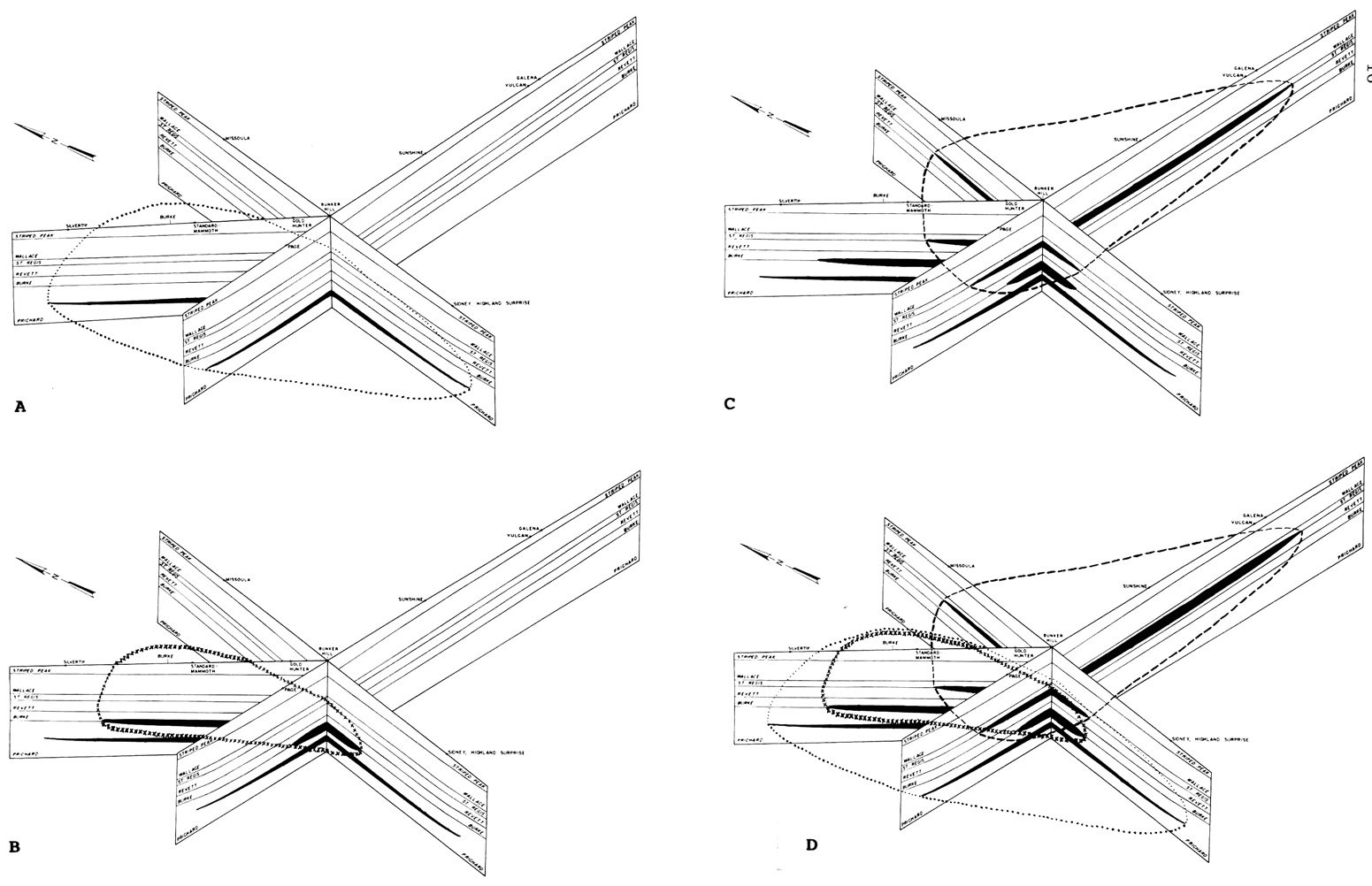
(Above) Diagram showing mineralized horizons in the Coeur d'Alene district (Bennett, 1984). Mineralization shown in black. (A) Generalized outline of the Middle Prichard basin, prefolding and faulting. (B) Generalized outline of the Prichard-Burke basin, prefolding and faulting. (C) Generalized outline of the Revett-St. Regis basin, prefolding and faulting. (D) Generalized outline of the Middle Prichard, Prichard-Burke, and Revett-St. Regis basins, prefolding and faulting.
Geology, Photos and History of Mining in the Silver Valley
Sunshine Mine
The Sunshine Mine was staked in 1884 by True and Dennis Blake, brothers from Maine, who had a homestead on Big Creek. In 1931, a major strike of rich silver-bearing ore was made on the 1700 level. The "Shine" has produced some 367 million ounces of silver, probably the largest silver production of any single silver mine in the world. By comparison, the fabled Comstock lode in Nevada produced about 200 million ounces of silver from many mines. Unfortunately, the Sunshine Mining Company ran short of ore in 1999, declared bankruptcy in 2000, and closed their office and the mine. The mine is now owned by the Sterling Mining Company and is being studied for possible reopening. In 2006, Sterling Mining Company began driving a decline (the Sterling Drift Project) from the Silver Summit Mine towards the main Sunshine mine as part of a major exploration project. The $2.8 million project was expected to take 15 months to complete. By September 2006, the drift was in some 1,100 feet and projected to go to 4,500 feet including some 1,200 feet of secondary drifts.
(Above) Headframe for the Jewell shaft and mill buildings of the Sunshine Mine, date unknown. The shaft was named for the engineer in charge of sinking the shaft.
(Above) Historical photo of Sunshine Mine.
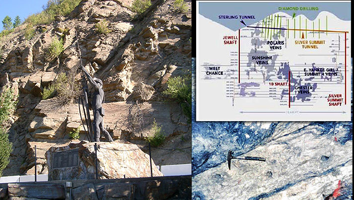
(Above) Memorial to the miners who died in the Sunshine Mine disaster (V.S. Gillerman photograph, 2005). Underground ore in the West Chance vein of the Sunshine Mine (V.S. Gillerman photograph, 1997). Note the sheared nature of the vein. Cross-section of the Sunshine Mine, showing the Sterling Drift and other workings (Bennett, 2006). Underground mining is difficult work and not without risk. In May 1972, a fire that killed 91 miners by smoke inhalation and carbon monoxide poisoning occurred at the Sunshine Mine. This was one of the worst mining disasters in history.
Bunker Hill Mine
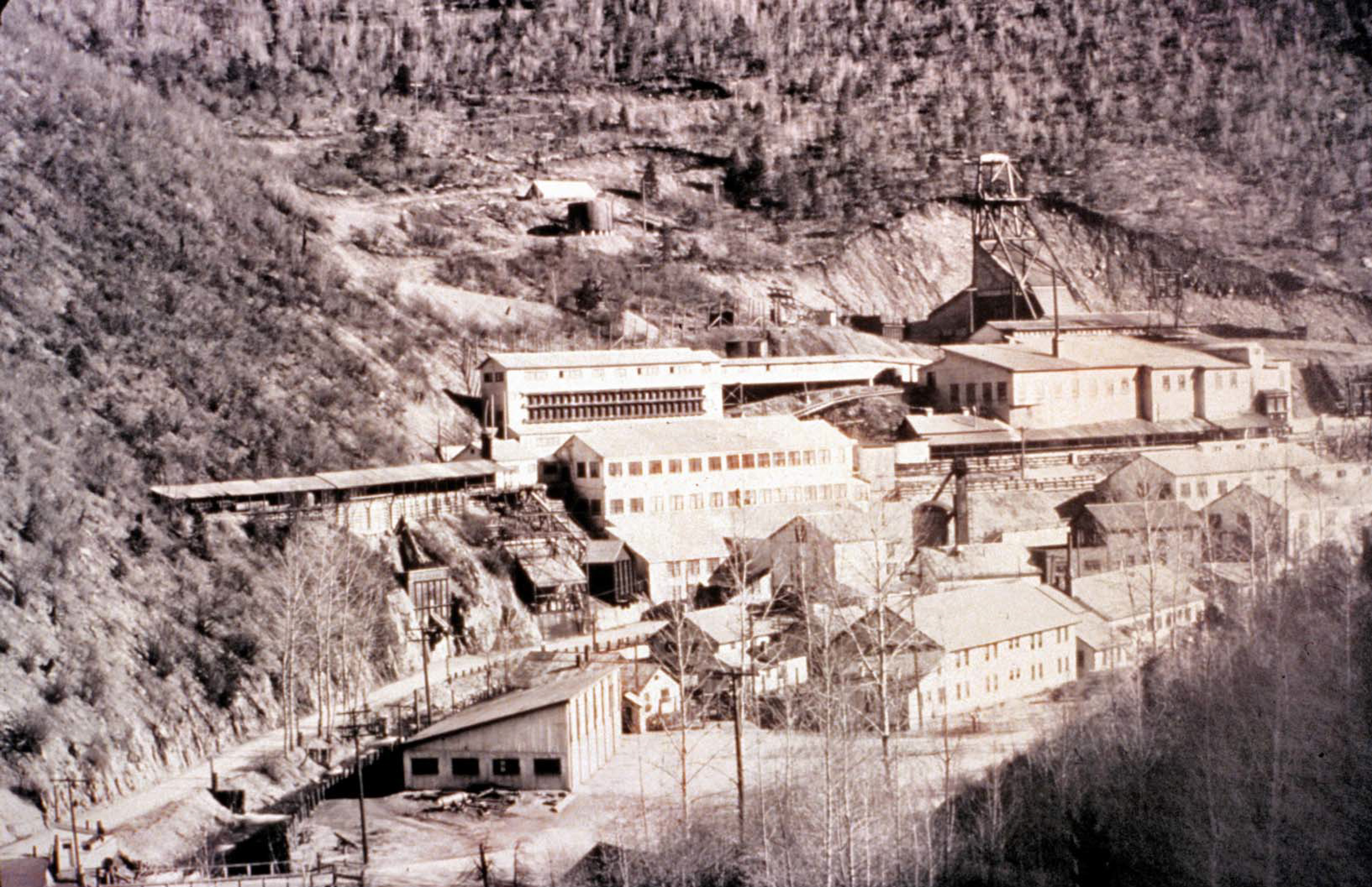
The Bunker Hill Mine was discovered in 1885. In 1887 Simeon Reed, a Portland Oregon businessman, purchased the mine and formed the Bunker Hill Mining and Concentrating Company. In 1903, the 2-mile-long Kellogg tunnel was completed, and the huge March ore body was discovered in 1904. Figure 20 shows the extent of the upper workings in 1908 or a little earlier. The company built its own smelter in 1917 and an electrolytic zinc plant (with Hecla Mining Company) in 1928.
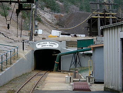
(Above) Portal of the Kellogg tunnel (M.J. Weaver photograph, 2005).
Both plants underwent substantial changes over the years, including the addition of the 715-foot-high stack at the smelter and the 610-foot-high stack at the zinc plant completed in 1978. Bunker Hill was instrumental in developing uses for zinc and contributed much to the zinc die-casting industry. In later years, sulfuric acid generated from the smelter was combined with phosphate ore from southeastern Idaho to make fertilizer. Gulf Resources and Chemical Corporation purchased the Bunker Hill Company in 1968, but closed the operation in 1981 with the loss of 2,100 jobs. When the mine and metallurgical complex closed, it was producing about 20 percent of the nation's refined lead and zinc and 25 percent of its silver. The mine was reopened in 1988, but closed again in 1991.
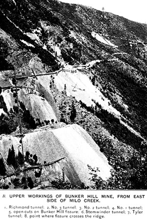
(Above) Historical photo of upper workings of Bunker Hill Mine, taken from east side of Milo Creek.
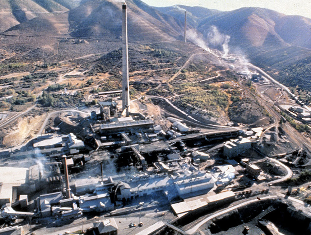
(Left/Above) Aerial view of the Bunker Hill smelter, circa 1984 (E.H. Bennett photograph). There are over 150 miles of underground workings (Figure 22), and it is the largest lead-zinc mine in the United States. An auction was held in 1991 and the mine was stripped. The New Bunker Hill Company purchased the mine and has been slowly refitting the underground facility for production. The mine still contains substantial reserves of zinc-rich ore (Bennett, 2006).
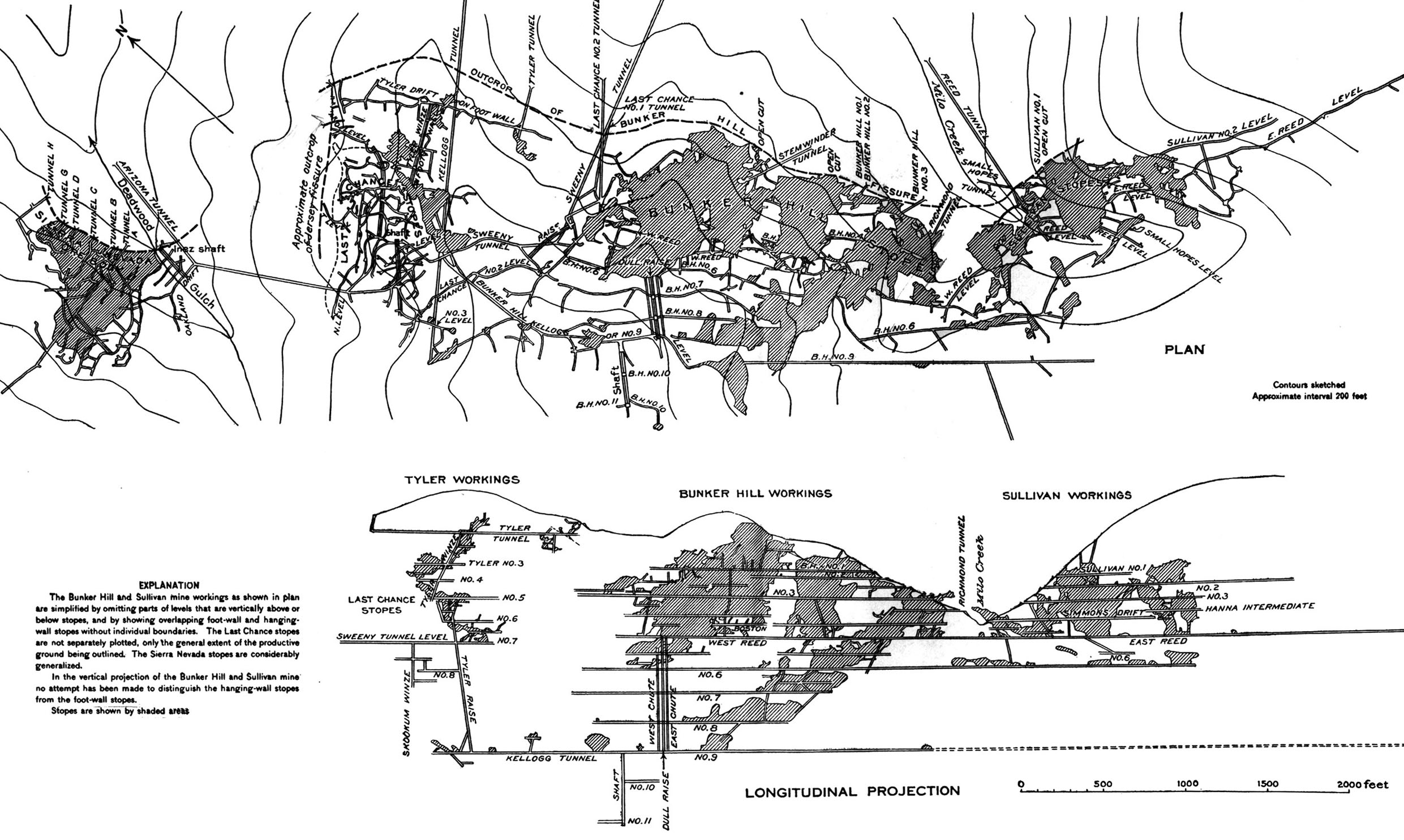
(Above) Map and cross-section showing the Bunker Hill Mine workings circa 1908 (Ransome and Calkins, 1908).
Star-Morning Mine
The Morning mine was developed in 1889 by Charles Hussey, a Spokane banker. After the mine was sold in 1897, a new mill was built, and the No. 6 tunnel was driven from the mill site near Mullan to the mine. In 1905, the mine (Figures 23 and 24) was purchased by the Federal Mining and Smelting Company, which merged with Asarco in 1953. At the Morning mill, Federal's metallurgists wrestled with the problem of separating zinc and lead from the complex ore. Selective flotation, discovered in the 1920s, solved this problem. In 1961, Hecla leased the mine and in 1966 purchased the property.
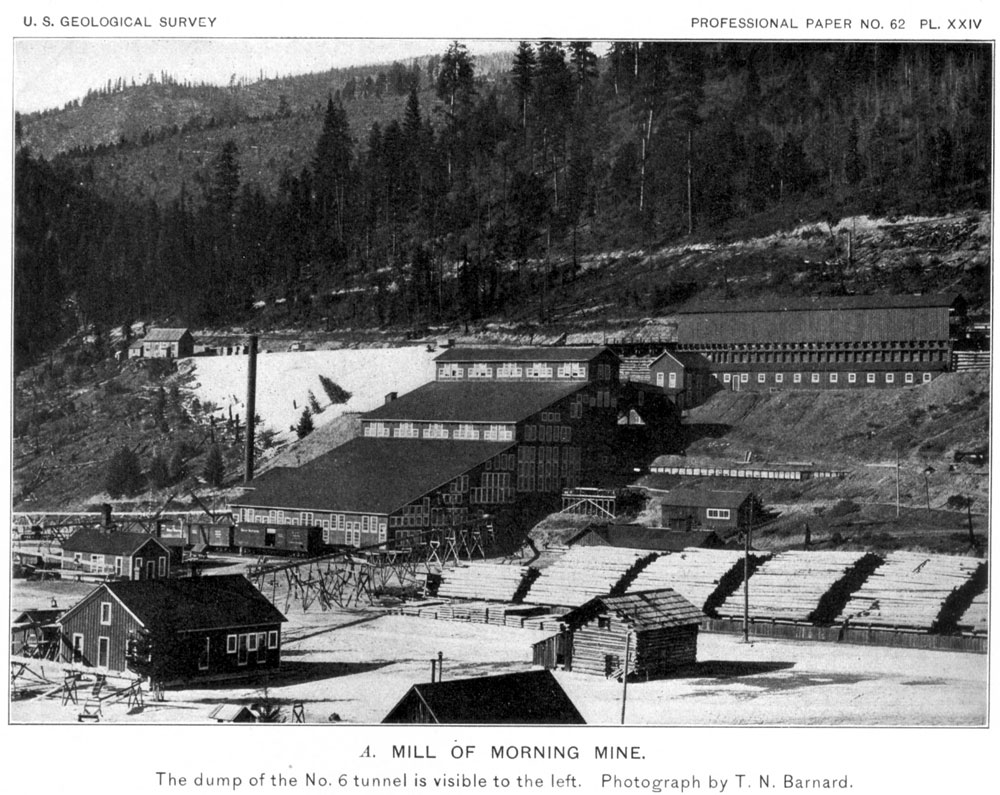
(Right/Below) Mill at the Morning mine, circa 1908 (Ransome and Calkins, 1908).
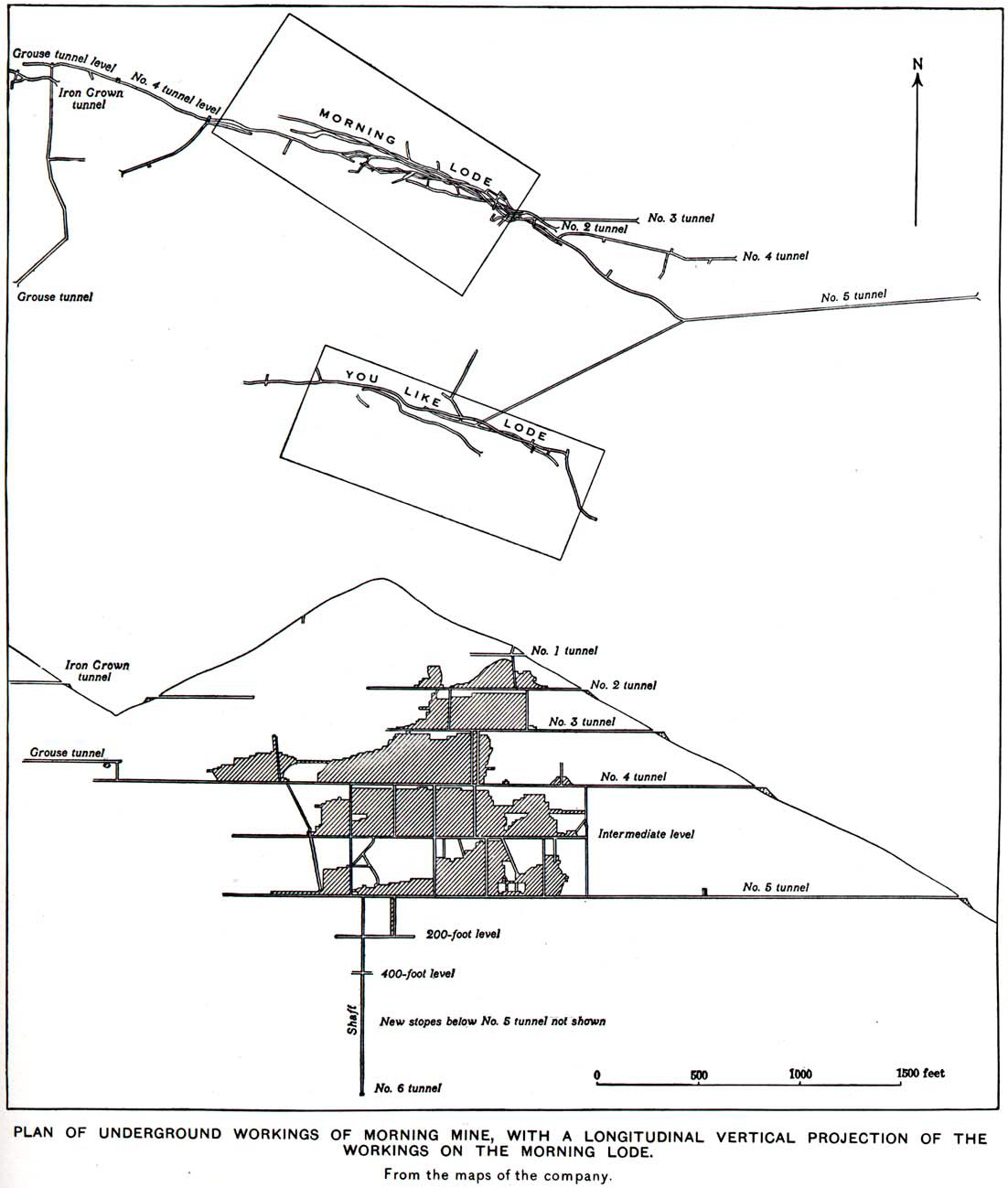
(Above) Plan and longitudinal vertical projection of the workings of the Morning Mine, circa 1908 (Ransome and Calkins, 1908).
The Morning mine and Star mine, both on the same orebody, were then operated as the Star-Morning unit. The Morning Mine on the east end of the orebody is lead/silver-rich whereas the Star Mine is zinc-rich. Fire destroyed the Morning mill in 1957. Hecla quit mining the Star-Morning in 1982. The Star-Phoenix Mining Company leased the mine, but the Star-Morning again closed in 1990. The Star-Morning has the second largest production in the district after the Bunker Hill (Bennett, 2006).
(Left/Above) Projection of underground workings of the Star and Morning mines between Burke and Mullan, Idaho (Bennett and others, 1989).
Galena Mine
The Galena Mine had been mined off and on until the Great Depression in the 1930s. In 1947, Asarco leased the mine, and a shaft sunk almost 3,000 feet found commercial silver ore. This new Galena Mine was placed in production in 1955 and was one of the largest producers in the district. This was due to Asarco's efficient operation and to more than twenty-two years of labor harmony. The mine closed in 1991 due to low metal prices, but was reopened in 1996 under a new partnership between Coeur d’Alene Mines Corp. and Asarco called Silver Valley Resources Corporation. In 1999, Coeur d’Alene Mines Corp. bought out Asarco’s interest in the partnership and took over operation of the mine.
In 2006, Coeur d’Alene Mines sold the Galena and Coeur mines and other holdings to U.S. Silver Corporation. The Galena is in full production and has developed significant new reserves for future operations. The mine employs about 180 people (Photographs by V.S. Gillerman, 2005 and Bennett, 2006).
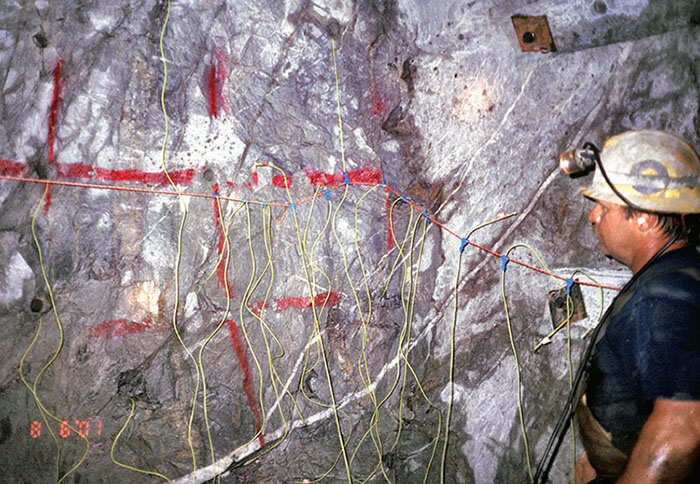
(Above) A loaded face at the Galena mine prior to being blasted (area where mine excavation is advancing). Large mucking machines are used to remove the rock after each blast.
Lucky Friday
Like the Sunshine and Galena mines, the Lucky Friday was a late bloomer. In 1912, the Friday was sold at a sheriff’s sale for $2,000 and again in 1936 for $120 in back taxes. In 1938, John Sekulic, a garage mechanic in Mullan, purchased the mine for $15,000 and formed the Lucky Friday Mining Company. With a lot of faith in the venture and enough technical and financial help from Judge Albert Featherstone, the president of Golconda Mining Company, mining began in earnest. The company shipped its first ore in 1942. The ore got better and better as the shaft went deeper.
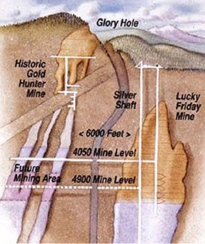
Hecla Mining Company started buying stock in the Lucky Friday, and in 1964 the two companies merged. In 1980, the company began sinking the $40 million "Silver Shaft" at the Lucky Friday. The shaft is now 6,000 feet below the surface and the main production shaft at the mine. The 140-foot-high headframe stands in contrast to the old hoist works visible on the hill behind the mine offices. The Lucky Friday produced over 125 million ounces of silver through 2002.
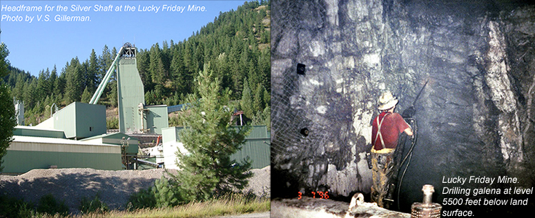
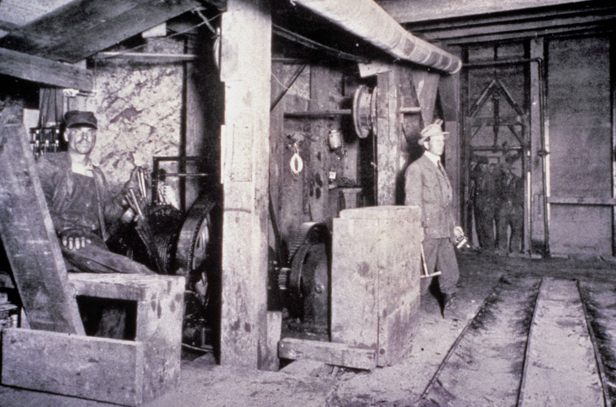
(Above) Headframe for the Silver Shaft at the Lucky Friday Mine (V.S. Gillerman photograph, 2005). Miner drilling vein at the 5500 level (feet below land surface) in the Lucky Friday Mine (V.S. Gillerman photograph, 1996).
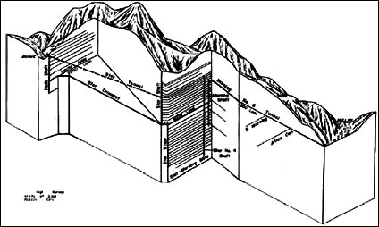
Gold Hunter Mine
The Gold Hunter was developed by Day Mines, Inc. The ore was rich, but spotty. In 1977, Hecla decided to look below the Gold Hunter mine for the downward extension of the Hunter veins. The exploration was successful. Today ore is mined from the 5900 level of the Hunter, and the mineralization extends to 7,900 feet. The Gold Hunter (Figure 33) is now the primary source of ore mined from the Silver Shaft at the Lucky Friday mine (Bennett, 2006).
(Right/Below) Diagram of the Gold Hunter and Lucky Friday workings.
Coeur mine
The Coeur Mine was placed in production in 1974. It was owned by Coeur d’Alene Mines Corporation and operated by Asarco until 1991. It opened briefly in 1996, but closed again because of low reserves. The Coeur produced about 2.5 million ounces of silver a year (Bennett, 2006).
Labor Strife
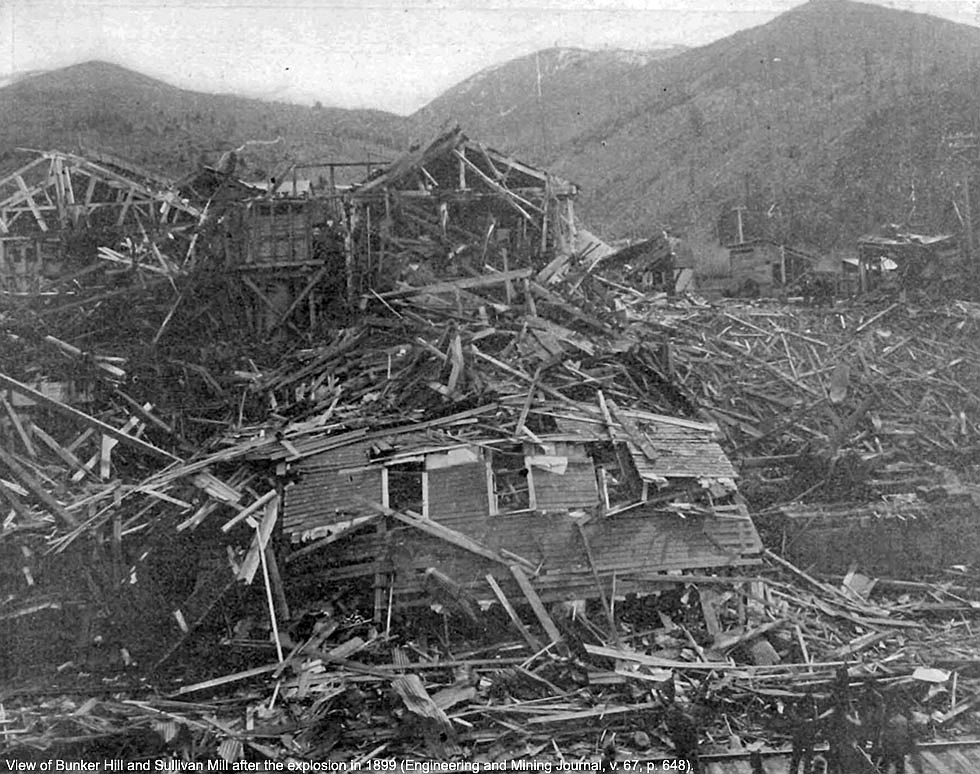
Labor unrest was a problem throughout the district in the 1890s, and martial law was declared on two occasions. In 1899 labor agitators destroyed the Bunker Hill mill with a massive explosion of dynamite (Figure 35). Attempts, often successful, to destroy property were a favorite tactic used by union organizers against companies whose management was opposed to having unions at their mines.
(Right/Below) Bunker Hill mill following explosion in 1899. (Engineering and Mining Journal, v. 67, p. 648).
Mining waste
Originally, the mills in the district dumped mill tailings (waste material) into the Coeur d'Alene River and its tributaries (Figure 36). Periodic flooding moved the metal-rich tailings through the drainage and into Coeur d'Alene Lake.
This contaminated the Silver Valley and the lake with metals. Around 1900, large wooden tailings dams were built on Canyon Creek and near Osburn and Pinehurst. These dams were frequently breached by spring runoff. In 1944, Hecla Mining Company built a sink-and-float plant near Osburn to reclaim zinc and lead from 2 million tons of old mill tailings that filled the valley. The plant produced substantial amounts of metals, but it burned down in 1948.
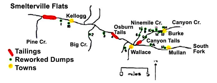
(Above) Location of tailings dams and of dumps reworked for additional metals in the Coeur d'Alene district (Bennett, 2006).
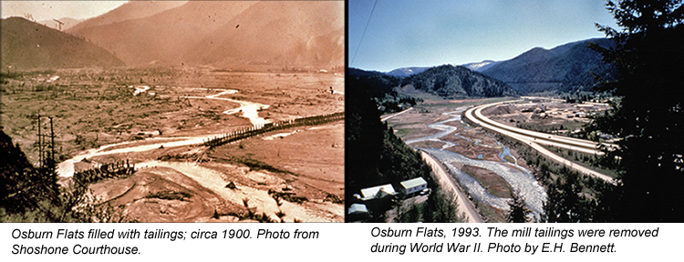
(Above) Images were taken looking east from Two-Mile Creek and show how Osburn Flats looked just after 1900 and again in 1993.
In 1982, the Environmental Protection Agency declared a 21-square-mile area that included the Bunker Hill smelter and zinc plant as a Superfund site. EPA, the state of Idaho, and the mining companies have contributed substantially to remediating the damage from past mining. Over 3,000 homes in the Superfund area have had the dirt in their yards replaced to decrease the problem of fugitive lead. The zinc plant, smelter, and concentrator have been removed as well as the tall smoke stacks (Figure 39). Thousands of cubic yards of contaminated soil from Smelterville flats has been excavated and placed in a repository, and millions of trees have been planted on the hillsides in back of the smelter and zinc plant.
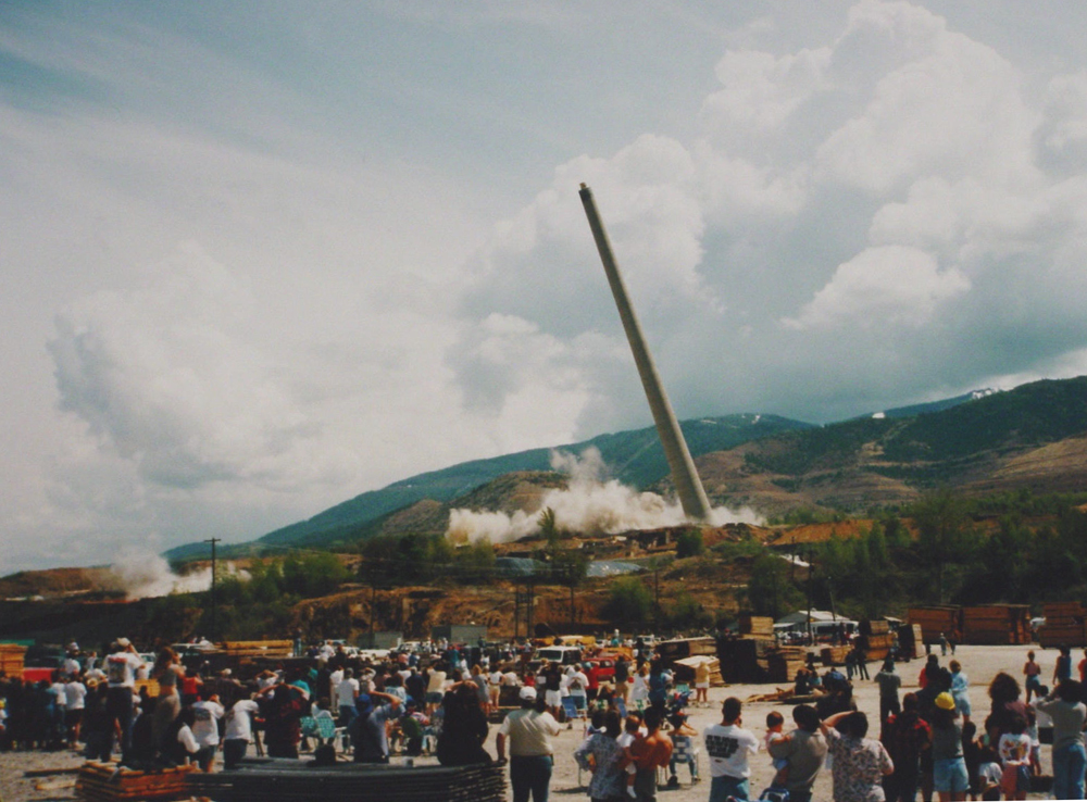
(Above) On May 26, 1996, the smoke stacks for the smelter and the zinc plant were dropped into trenches and buried (E.H. Bennett photograph).
Continue to Module 8 - Challis Volcanic Group
References and further reading
Bennett, E.H., 1984, A hypothesis concerning the genesis of orebodies in the Coeur d'Alene mining district, Idaho: Idaho Geological Survey Technical Report TR-84-7, 39 p.
Bennett, E.H., 2006, The fabulous Coeur d’Alene district: Presentation for North Idaho Chamber of Commerce Legislative Tour, November 2006, Post Falls, Idaho, 35 p.
Bennett, E.H., P.L. Siems, and J.T. Constantopoulos, 1989, The geology and history of the Coeur d’Alene mining district, in V. E. Chamberlain, Roy M. Breckenridge, and Bill Bonnichsen, editors, Guidebook to the Geology of Northern and Western Idaho and Surrounding Area: Idaho Geological Survey Bulletin 28, p. 137-156.
Bennett, E.H., and Venkatakrishnan, 1982, A palinspastic reconstruction of the Coeur d’Alene mining district based on ore deposits and structural data: Economic Geology, v. 77, p. 1851-1866.
Doughty, P.T., and Price, R.A., 2000, Geology of the Purcell Trench rift valley and the Sandpoint Conglomerate: Eocene en echelon normal faulting and syrift sedimentation along the eastern flank of the Priest River metamorphic complex, northern Idaho: Geological Society of America Bulletin, v. 112, no. 9, p. 1356-1374.
Doughty, P.T., Price, R.A., and Parrish, R.R., 1997, Geology and U-Pb geochronology of Archean basement and Proterozoic cover in the Priest River complex, northwestern Unite States, and their implications for Cordilleran structure and Precambrian continent reconstructions: Canadian Journal of Earth Science, v. 35, p. 39-54.
Fleck, R.J., R.E. Criss, G.F. Eaton, R.W. Cleland, C.S. Wavra, and W.D. Bond, 2002, Age and origin of base- and precious-metal veins of the Coeur d’Alene mining district, Idaho: Economic Geology, v.97, no.1, p. 23-42.
Hobbs, S.W., A.B. Griggs, R.E. Wallace, and A.B. Campbell, 1965, Geology of the Coeur d'Alene district, Shoshone County, Idaho: U.S. Geological Survey Professional Paper 478, 139 p., scale 1:24,000.
Orr, W.N., and Ore, E.L., 2002, Geology of the Pacific Northwest: 2nd Edition, McGraw-Hill Higher Education, 337.
Ransome, F. L., and F. C. Calkins, 1908, The geology and ore deposits of the Coeur d'Alene district, Idaho: U.S. Geological Survey Professional Paper 62, 203 p.
White, B.G., 2000, Coeur d'Alene mining district: product of preconcentrated source deposits and tectonism within the Lewis and Clark line, in Sheila Roberts and Don Winston, eds., Geologic field trips, western Montana and adjacent areas: Rocky Mountain Section of the Geological Society of America, University of Montana, p. 95-101.
Winston, Don, 2000, Belt Supergroup stratigraphy, sedimentology, and structure in the vicinity of the Coeur d’Alene mining district, in Sheila Roberts and Don Winston, eds., Geologic field trips, western Montana and adjacent areas: Rocky Mountain Section of the Geological Society of America, University of Montana, p. 85-94.
Wyld, S.J., Umhoefer, P.J., and Wright, J.E., 2006, Reconstructing northern Cordilleran terranes along known Cretaceous and Cenozoic strike-slip faults: Implications for the Baja British Columbia hypothesis and other models, in Haggart, J.W., Enkin, R.J., and Monger, J.W.H., eds., Paleogeography of the North American Cordillera: Evidence for and against large-scale displacements: Geological Association of Canada, Special Paper 46, p. 277-298.
Credits
This page was originally created by Victoria E. Mitchell and Reed S. Lewis, Idaho Geological Survey and Joe Larsen, Idaho State University; it was modified and updated by Dave Pearson at Idaho State University.