Idaho State University Ph.D. student Chris Tennant’s research on snowpack measurement recognized
November 20, 2018
Big data equals better forecasting and a boon for water managers
POCATELLO – A research paper that uses data collected by lidar imaging to better measure snowpacks in Western U.S. mountains by former Idaho State University geosciences graduate student Chris Tennant has received a 2017 Editor’s Choice Award by the journal Water Resources Research.
Only about 1 percent of articles published annually in the journal receive this recognition.
The selection by the editors of the journal is “based on technical significance, novelty, originality, presentation, and broader implications of the publication.” The work will be highlighted at American Geophysical Union Hydrology Section business meeting in December.
The title of Tennant’s paper was “Regional sensitivities of seasonal snowpack to elevation, aspect, and vegetation cover in western North America” and it included three ISU geosciences faculty as co-authors, Kathleen Lohse, Sarah Godsey and Ben Crosby. It included data collected at the Reynolds Creek Critical Zone Observatory in Southwest Idaho.
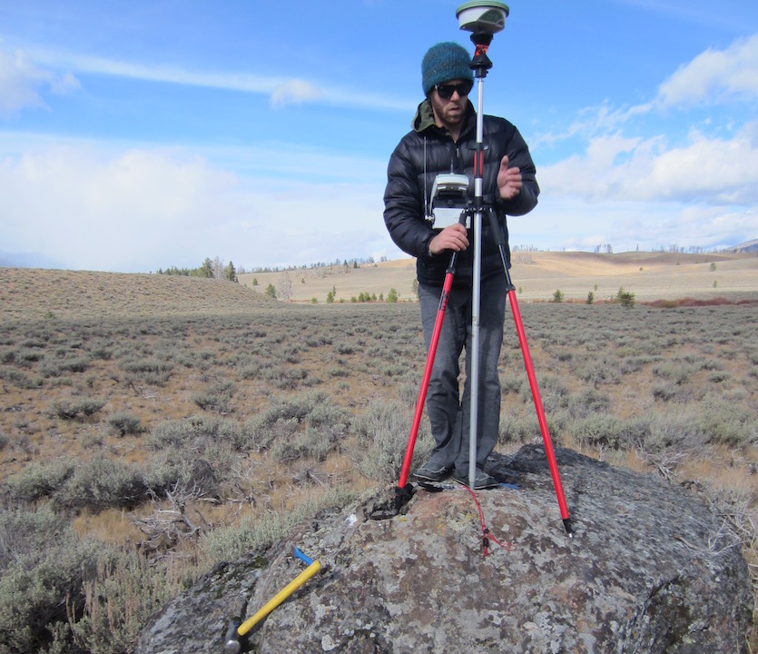
“The ability to be able to account how much snow covers the ground over large areas has radically changed with the use of lidar,” Tennant said. “We’ve gone from measuring snow depth in watersheds at points that are 3-feet-by-3-feet to measuring at the scale of whole watersheds, 50-100 square miles.”
The data Tennant analyzed was collected by planes flying over watersheds using light detection and ranging (lidar), which is a surveying method that measures snow depth by using pulsed laser light. Prior to the use of lidar, scientists estimated the snowpack by sticking pipes in the ground that measured snow depth at various sites, and then made assessments of the total snow pack based on these individual sites.
“Chris’s project evaluates at a foot-by-foot scale how thick the snowpack is over a large area well beyond what humans could go out and physically measure,” said Crosby, who was Tennant’s advisor at ISU. “So now we have a continuous measure of how thick the snow cover is over a given landscape.”
 Tennant found it makes a big difference in a watershed if there is vegetation or not, what direction the slope is facing and what elevation it is and how these factors influence the thickness of a snowpack. Knowing the thickness and other characteristics of a snow pack better allow scientists to more accurately estimate its water content.
Most water in the West used for everything from municipal water supplies to irrigation and industrial uses comes from the mountain snowpacks. Thus, the more accurately the snowpack is measured, the better able managers and others can forecast the amount of water that will be available during the year, which is extremely important for flood control and the waters’ many uses.
“Chris’s work improves the ability to forecast how much water a given winter’s snowpack will yield and provide for the demands downslope,” Crosby said.
For example, in his current position for the U.S. Corps of Engineers, Tennant uses the data collected from lidar surveys to help determine the water release from the Corps’ dams in California.
Tennant credited his collaborators and those who have collected the lidar data across the West for the success of his paper. He and Crosby estimated the cost was in the millions of dollars for collecting the data that was analyzed in the paper.
“I think it is really important to emphasize how much work has been done to generate those data sets and make them available,” Tennant said. “This paper would not have been produced if it wasn’t for all the work that went into that.”
These new snowpack data sets could also be valuable for helping to predict how climate change could impact Western watersheds in the future, in part because they measure watersheds at lower and higher elevation levels than the way the watershed snow packs were measured historically. This will help scientists to more accurately measure the water content of regional snow packs in the future.
“This study demonstrates the utility of airborne lidar surveys for evaluating how physiography and regional climate interact to determine watershed‐level snow distributions and helps better inform how climate will affect vital western U.S. snowpack and water resources,” Tennant states in the article.
Besides the ISU contingent of co-authors, Tennant also collaborated with Adrian Harpold at the University of Nevada, Reno; Laurel Larsen, University of California, Berkeley; Paul Brooks, University of Utah; Robert Van Kirk, Humboldt State University, California; and Nancy Glenn, Boise State University.
“This is an example of the type of project enabled by community data resources,” Crosby said. “Science is no longer done by one or two people who are just slaving away by themselves in a laboratory. Now it is typically a multi-disciplinary, multi-institutional endeavor for projects that are trying to cross between disciplines and regions. Using these types of data sets is an example of one of those projects succeeding because of being inclusive rather than exclusive.”
Tennant, a native of North Carolina who earned his bachelor’s degree at Western Carolina University, earned his master’s degree in geosciences from ISU in 2011 and his Ph.D. in geosciences in 2015. The article recognized was part of his Ph.D. thesis work. Tennant now works as a water control data systems administrator for the U.S. Army Corps of Engineering in its Sacramento, California, District Office and is completing post-doctoral research at the University of California, Berkeley
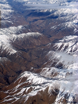
Bottom photo information: Photo of Middle Fork Salmon River watershed provided by Ben Crosby, showing the exact kind of conditions studied for this research – how does snow cover vary with elevation, facing direction and vegetation.
